
|
|
2019 has got off to a very exciting start thanks to a much anticipated return to cold weather. On January 21st an Arctic air mass had advected across N. Ireland bringing with it unstable cold air. When frigid air moves across a warm surface like the Atlantic ocean then convection will occur, air parcels rising in response to steep lapse rates and aided significantly with wind shear and troughs allow for the formation of cold air mass convective cells in the form of showers and thunderstorms. GFS had indicated +200 surface based CAPE, a lifted index of -1 and shear increasing into the night. This turned out to be my first storm chase of the season, I ended up targeting the north coast to get the best view of these incoming cells, I teamed up with photographer Nigel McFarland and together we spent the entire day shooting stills and time-lapse of very decent convection, this shoot lasted well into the night and finally ended at 00.30 UT after a full 12 hours of photography and sky watching, however I will save this adventure for another report.
As I drove home during the early hours of January 22nd I was expecting a treacherous drive back through ice, I also expected inland areas to be covered in snow however I was disappointed to see none at all with only a light sugar coating on the roads closer to home, temps ranged from 0 to -1C, I could see a great clear sky and the moonlight revealed no snow on the mountains. I decided I wouldn't be getting up early the following morning to target rush hour traffic as there simply wasn't enough snow. By late morning of the 22nd I checked social media expecting nothing of interest, however as time went on I observed an increase in snow reports across parts of the N and W over higher ground, the local forecast showed regular snow showers for my area for the remainder of the day which was backed up by GFS, furthermore the radar showed good heavy snow showers building in the W and moving E on the NWly/Wly surface flow, I reckoned the potential was there for snow photography so I decided to make a day of it. I packed the camera gear, drone, shovel, tea and snacks etc then picked up my Mother and our Dog Rhua to take them out for the day, after all, Rhua is mad about snow and hadn't seen any since February last year.
We drove along Glenshane Pass into a world of snow, there was a respectable layer down despite the roads being clear, on an instinct I continued W as I wanted to check out my old favourite friend Benbradagh located outside Dungiven. This mountain is very photogenic and more often than not is prone to a snow, I also wanted to get my first footage of snow using the new Mavic 2 Pro so I was eager to get in the air. Benbradagh did not disappoint, we arrived under cloudy skies but the atmosphere felt dynamic and I suspected a change was on the way, we drove up the mountain as far as we could until the wheels lost traction and the van could climb no further up the steep gradient, so I carefully parked near a gate and got outside for a look at the sky. Our timing had been perfect, as I watched the clouds blew away and pristine blue skies appeared with sunshine illuminating the clean fresh snowfall on the mountain, the scene was terrific and just what I had hoped for, in fact, it was even better than that.
 |
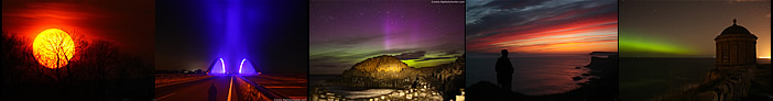
I powered up the Mavic and got in the air after warming the batteries first to reduce the chances of a low battery temperature warning which could result in a forced landing, once everything looked good I flew off and had a fantastic aerial encounter with this snow-covered mountain, this place has been so good to me in the past and it was being good to me yet again. I ended up doing two flights and burning through two batteries, I filmed video and took aerial stills and even experimented with drone panos, something I had never done before in the snow. The Mavic takes ten 20MP images in 180 degree pano mode then stitches the images together into a pano all onboard the aircraft for you, the entire process from taking the images to rendering is only 30 seconds or so which is amazing, the drone also saves the individual files in a folder so you can create a pano yourself later at the computer, pretty impressive technology. The result above is covering a massive area of the horizon, literally 180 degrees of sky, I was able to get both summit peaks within the frame which made for a very unique image.
 |
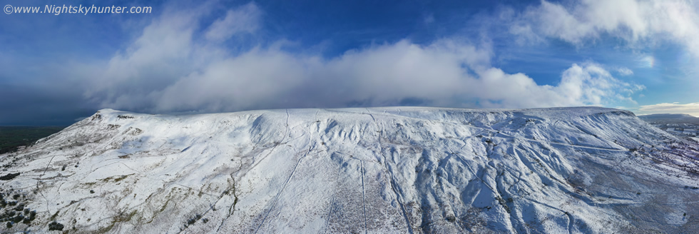
During the course of these flights I got treated to one hour of blue skies, I was actually shocked at the strength of the January sunshine, unbelievably it was melting the snow even at this altitude, this pano was taken from a different angle, just look at the difference in snow coverage in comparison to the first image. Despite the snow melting on the flank I actually preferred this angle showing the entire structure of the mountain. You can't appreciate the detail in these resized 980 pixel images, the true pano is massive in size at over 8000 pixels in length and sporting incredible detail and resolution, in the high resolution images I can zoom far into the mountain and examine fine detail then scroll across to take in the entire panorama, it really is an experience and would make for a fantastic large format print.
 |
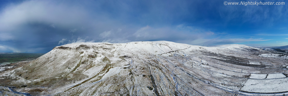
During this time I had been lost in the world of droning and was paying little attention to the sky, the wind was calm and the light was nice so I was quite fixated on the aerial side of things. I moved the drone around the peak and suddenly I saw that the sky was talking, in fact, it was screaming that something was changing. This last pano I captured actually sums up the scene which was about to unfold, in the distance is a large developing cell, it came off the Atlantic Ocean where it was getting fed by moisture and instability, it got lifted by the landmass of Donegal and entered the area of Lough Foyle where more moisture and warmer water combined with differential heating combined to create a breeding ground for this cell. As it grew in height the upper levels winds blew the cell's anvil downwind for many miles encouraging lift, parcel mixing and evolution of the updraught and downdraught system into an organized machine.
It was only later that I learned that the set-up was more than conducive to convection, I had assumed that the CAPE we had been hunting in moonlight the night before was the main event as GFS had showed it waning by morning, in fact, we would be lucky to get 50 j/kg of CAPE this afternoon, however other forces were at work. Steep lapse rates encouraged rapid vertical growth of updraughts however it was the speed shear which tipped the scales. Wind shear is a change in direction or speed of wind with height, if wind shear is present then the updraught gets orientated away from the vertical plane and becomes slanted allowing precipitation to fall away from the updraught base which results in organization and a greater chance of severity. I found out later that there was 100 knots of deep layer shear within the first 0 to 6km of the atmosphere. To put this in perspective a multicell storm requires 20 knots or more of shear and a supercell is likely with 40 knots of shear, so you can imagine that 100 knots was more than compensating for the lower CAPE qualities, in fact, time and time again, it is these low CAPE yet high shear set-ups which produce the best surprises in this country, including tornadoes and severe flooding events from back-building storms, however shear is also good for storm structure, and it was this that would make my day. The annotated pano above explains the wind shear, not only was it very strong but the shear was also directional, check out the size of that anvil, it was already over Donegal yet blowing so far down range it passed to the right of Benbradagh's peak and beyond the huge horizontal extent of the Mavic's FOV.
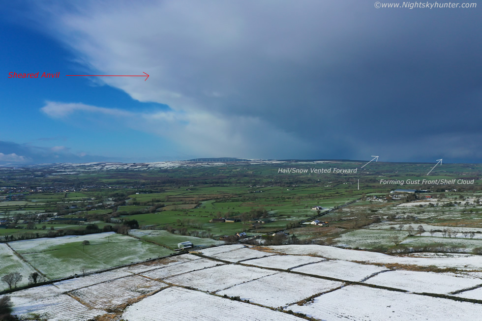 |
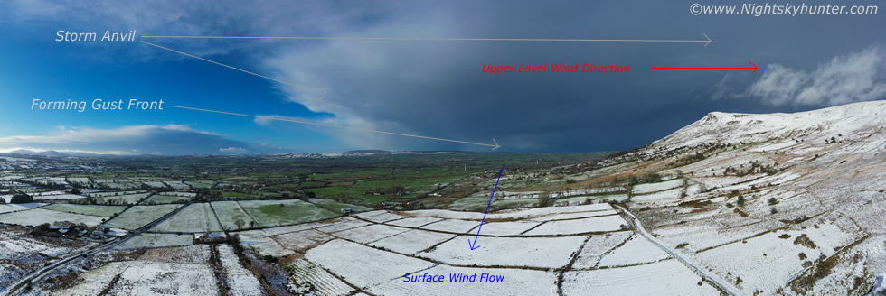
This is one still taken from the ten stills captured by the drone to make the pano. At this stage I began to get excited, I immediately noted solid cloud structure on the horizon which seemed to be located directly over Lough Foyle, to the left of this was a curtain of hail and snow falling and aloft was a sheared anvil and that curtain of precip was rapidly heading my way. I wasn't expecting anything dramatic, I just assumed it was another snow shower on the way however I was aware that these big showers are often high precipitation events which are often accompanied by gusty outflow winds which could cause serious problems for my drone, so anticipating trouble and despite plenty of battery remaining I decided to land the drone just to be safe, once the snow passed I planned on taking it out again. In the meantime I began charging the battery with the car charger and made my Mother and I a mug of tea from the flask then enjoyed the view of the snow.
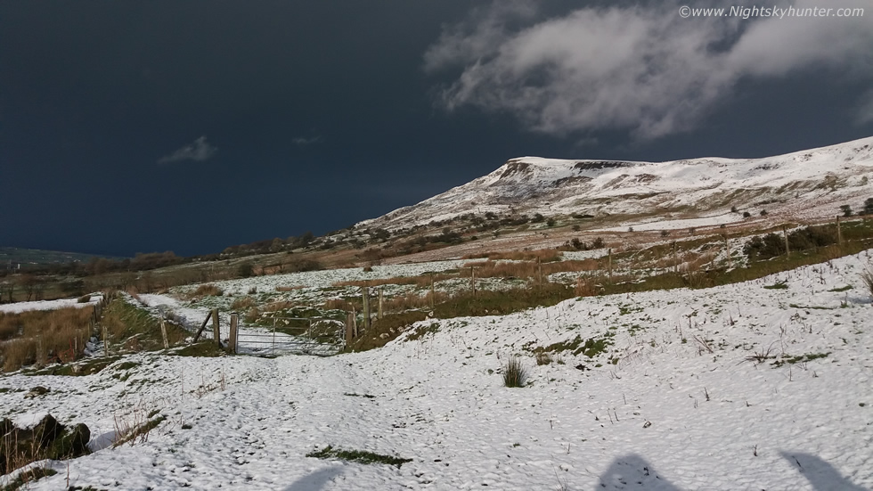 |
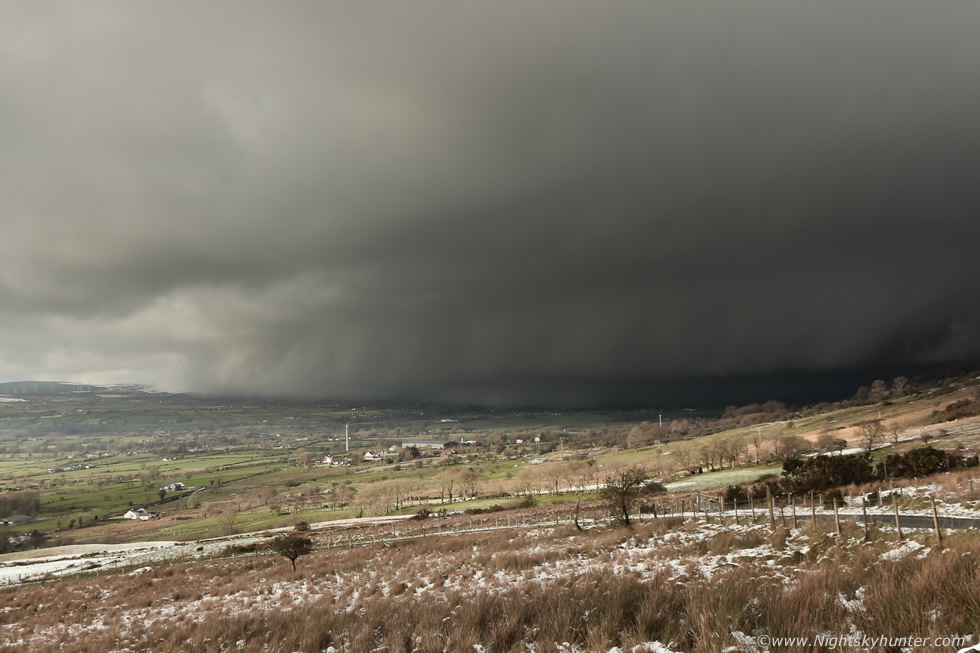
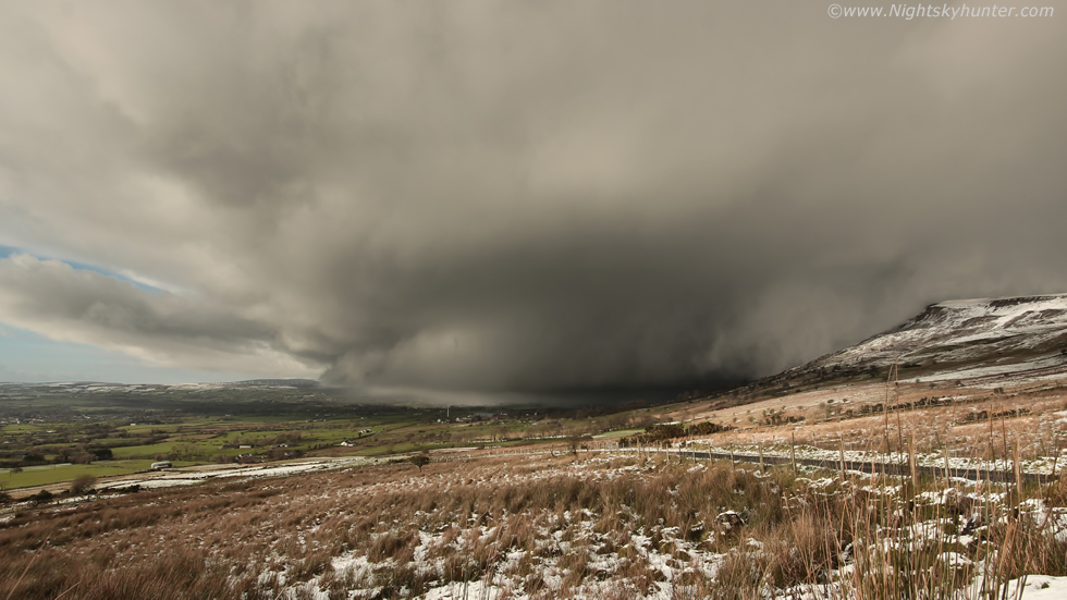
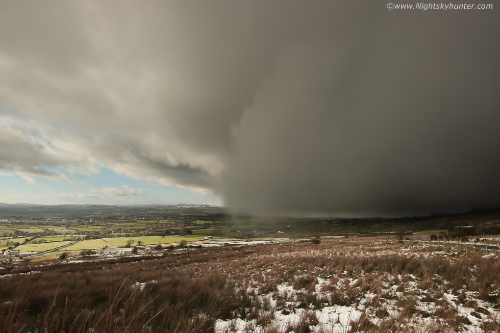
Fifteen minutes later I looked behind me and saw a very foreboding vista, the mountain top was glistening white in the sunlit snow however behind the peak the sky was suddenly black and menacing. I finished my brew and had one more look before taking shelter in the van, it was then that I observed a gust front marking the leading edge of the cell, despite being 15 miles away I could see it growing angrier my the minute as it scooped up moist surface air and lifted it upward forming a long low menacing cloud called a shelf cloud (Arcus cloud) which marked the gust front region. I knew from its appearance that something exceptional was happening and that shelf cloud was moving towards me rapidly, I didn't have much time.
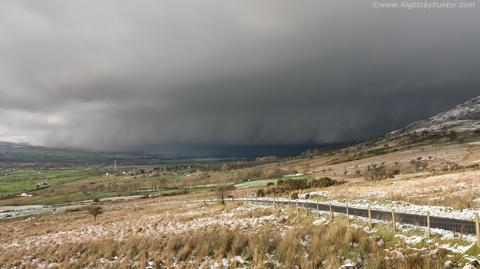 |
I drove to the highest vantage point I could get before the wheels spun out then orientated the van facing the advancing cell, switched on the window-mounted Go-Pro to record video, grabbed my camera and tripod, then jumped over a gate into a field overlooking the wild flank of the mountain and got my gear set up, it was a frantic rush as I knew I didn't have much time, the wind was up, it was getting darker and colder and I sensed I soon would be getting blasted by snow, the only thing going through my mind was ''time-lapse'', I needed to get this on camera fast. I switched to my 18-55mm kit lens and zoomed into about 24mm approx and began shooting at a rate of one image per second. My mind was concerned about settings etc so I wasn't really looking skyward until I heard the familiar click click click of the shutter, then once content I looked up and saw this. I was blown away by the meanest shelf cloud I have seen in years, as the DSLR kept shooting I pulled out my phone and began taking images and video to document the storm, this is a phone shot.
 |
These are from the DSLR, I couldn't believe my luck this day, I just went out to get a few images of the snow, I was already very happy and content with the drone footage of the mountain so I wasn't expecting anything to surpass that, then this beast comes in and takes me completely by surprise, what a treat!
 |
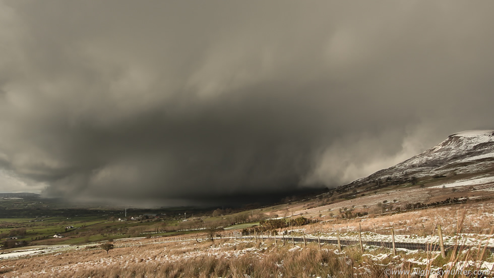
That shelf is almost on the ground here which indicates a rich supply of moisture at the surface and plenty of forcing within to produce a structure of this caliber. You don't get structure like this from a weak set-up, this is the result of organization, nature had formed a winter precipitation machine. Many people new to storm structure identification get confused between wall clouds and shelf clouds, surely this is a wall cloud because it looks like a long wall?, in truth I admit the naming is somewhat misleading and confusing, however I will try my best to clarify the difference.
A wall cloud is an inflow based structure whereas a shelf cloud is outflow based. A wall cloud is an abrupt lowering under the updraught base of a thunderstorm, most often but not always in the rain-free area, near the rear or flanking area of the storm. The wall cloud is a visual indication of inflow feeding into the storm, its associated with rising warmer air in the vertical axis and the lowering is always tilted towards the area of precipitation, if you see a wall cloud keep watch, if it is rotating strongly then it could produce a funnel cloud or a tornado. A shelf cloud is associated with a storm's downdraught at the forward end of the cell and forms when cold descending air (the gust front) mixes with warm moist area in front which forms the menacing cloud, shelf clouds always point away from the precipitation area and are associated with strong outflow, shelf clouds are among the meanest looking clouds in nature, in some cases they can be menacing but they are also a visual warning of incoming strong winds, rain, hail or lightning, I hope this explanation helps, now back to the storm.
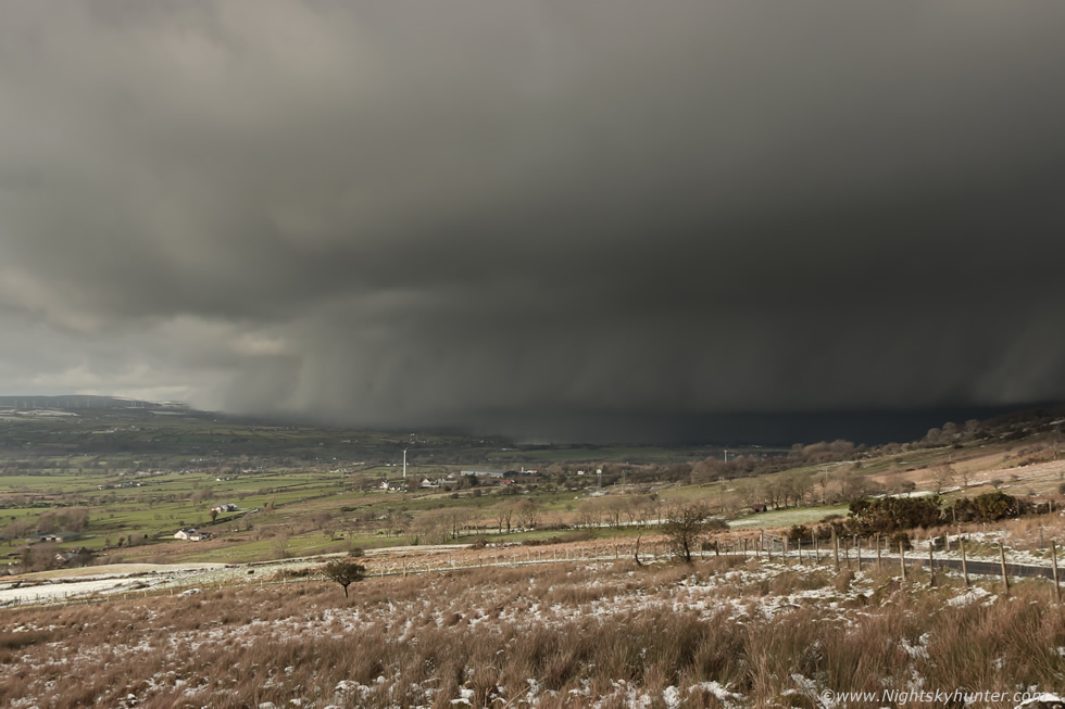 |
I was glad I had packed the drone away when I did as a bitter wind was now blowing hard, look at that structure, it looked like something straight out of the USA. I have seen several spectacular shelf clouds over the years from N. Ireland however they have always been associated with big summer-time multicell thunderstorms becoming outflow dominant. I would have been thrilled to see something like this in June, but to witness this structure in January was simply beyond anything I had anticipated, I was thrilled beyond words, in fact, if it wasn't for the patchy snow on the ground you would be forgiven for thinking this was a storm brewed from a highly unstable hot summer's day.
 |
This is a crop from another DSLR frame, wind was starting to buffet the camera, I began holding the tripod mount steady incase it destroyed my time-lapse. I didn't even know if I would have enough frames for a lapse but I kept shooting anyway, the shelf was beginning to fill the field of my kit lens and would be too big soon.
 |
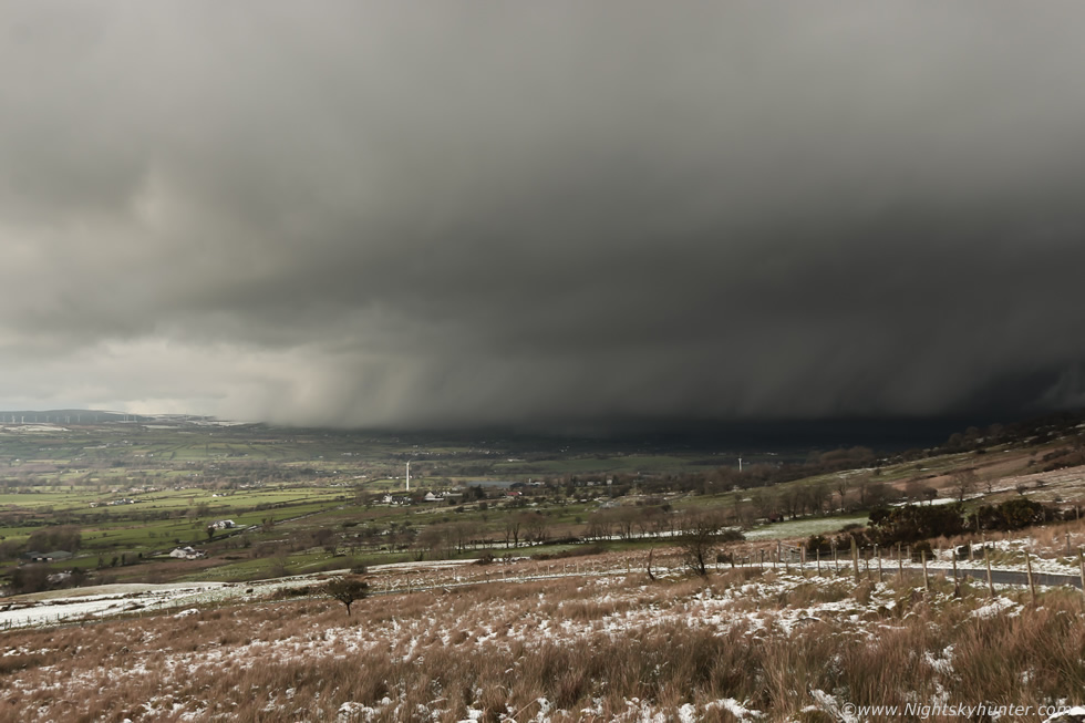
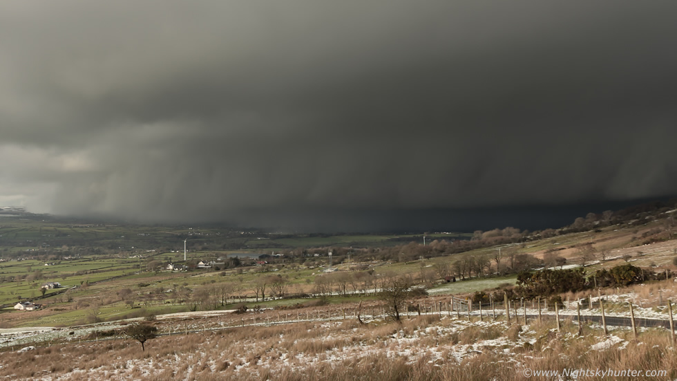
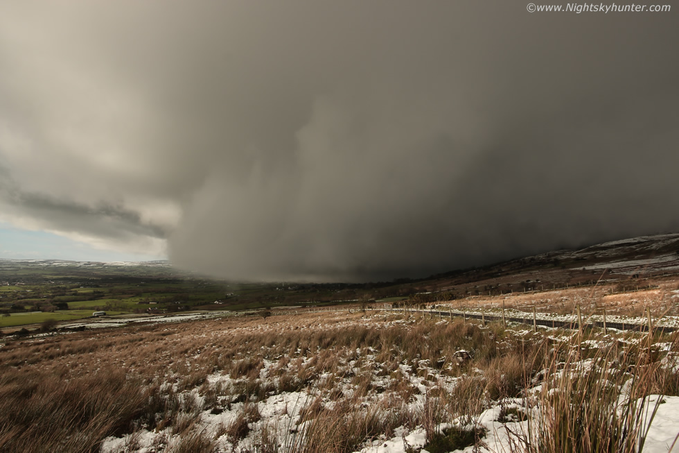
What an epic scene to the naked eye and on camera, as I watched I saw dramatic motion within the shelf as it exhibited forward scooping motions, above the shelf a pronounced tier or lip added to the scene with multiple layers of structure. Meanwhile a huge wall of what looked like snow or hail was plummeting the countryside below, as the outflow neared the wind raced blowing the wild grass horizontally and taking the air from my chest as the temperature dropped like a stone, I didn't have long left to get the frames I needed.
 |
The storm completely dominated much of the skyline and was huge, I quickly switched over to the Samyang 10mm F/2.8 wide angle lens, stopped the aperture down to F/11 and began a second time lapse. Solid dramatic cloud structure from the surface through the mid levels and up to the huge anvil, this cell was showing off big time and changing appearance in real time, it looked great with the clear blue sky further SW, I can tell you rite now this entire scene had already made my Winter, nature was showing off and I was loving it.
 |
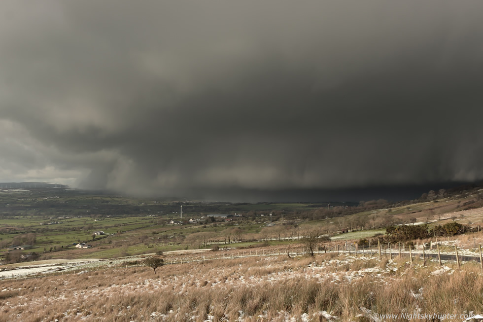
I wouldn't like to be standing on the summit at this point in time. Even if you could get your car to the top in the snow you would still have a good 1km walk back through winter hell with that storm impacting you, it wouldn't be a nice experience, period. What astonished me was the motion of the brighter cloud to the right, as the outflow winds spread across the landscape like an invisible pancake of air it encountered the steep cliff face and was quickly lifted aloft at a high rate of speed. I witnessed this happening and for the second time this day I was blown away, as I watched the white clouds blew over the summit at remarkable speed like smoke from a wild fire blowing in strong wind, it was difficult to describe and was strictly an experience that can only be appreciated by being here. Nigel McFarland and I witnessed a similar phenomena from a prolonged thunderstorm at this exact location during June 2018.
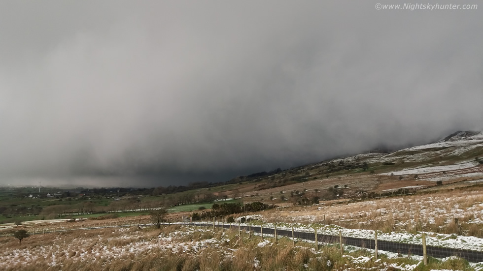 |
Mobile phone capture of a barrage of hail and snow overtaking the summit and about to hit me, I had minutes left and tried to hold out as long as I could to get as many frames as possible.
 |
The entire gust front feature was so close it covered everything, the mountain was gone and most of the skyline to the right of Benbradagh was invisible, I was almost inside the guster.
 |
I quickly stopped the lapse, turned around ninety degrees to my left and shot a very short lapse as the storm engulfed the blue sky. My world turned dark, the wind howled, I got slapped in the face by icy precip, I grabbed the camera, cleared the gate and got back inside the van with my adrenaline pumping, that was one heck of an experience. The van was exposed to a long duration assault of frozen pea-sized hailstones then snow, and just as I thought I had experienced it all a big angry rumble of thundersnow growled through the blowing snow from the direction of the summit, it was like a muffled rumble but very distinctive, there's something extremely unique about the sound of thunder through snow, the acoustics are special, there's nothing else like it, not to mention the fact that it's rare, I cant recall the last time I heard thundersnow so clearly, it may go as far back as 2010!
It snowed for the rest of the day and never relented, this storm brought a big transition and that was the last I saw of blue skies this day. The same storm produced more thundersnow over Swatragh and an old school friend of mine actually captured it on video while recording his children playing in the snow, that was a rare catch indeed. More thundersnow was heard in the Co. Down area from a separate cell so it turned into quite a day of surprises, but not only that this day also produced my first blue sky snow footage with the Mavic 2 Pro and my best ever Winter storm structure captured to date. As daylight faded I went home for dinner, warmed up, topped up my camera batteries then later I teamed up with Nigel McFarland and John fagan on Glenshane Pass where we shot images and time-lapse of an old derelict house in moonlit snow which made for the perfect end to the perfect day.
Mavic 2 Pro drone footage of the fresh snowfall on Benbradagh surrounded by blue skies during that wonderful hour of nice light. Towards the end of the footage you can see the distant storm growing in the sky with it's large anvil taking shape against a backdrop of two snow-covered mountain summits.
Footage of the thundersnow shelf cloud approaching, featuring DSLR time-lapse, Go-Pro time-lapse and mobile phone footage. The DSLR lapse turned out a success although I wish I had been lapsing it for much longer or began shooting at an earlier stage, but considering the fast forward speed of the storm I think things worked out very well. I obtained 11 seconds of footage with the kit lens and 7 seconds of footage using the 10mm.
Time-lapse sequence of the derelict house in moonlit snow on Glenshane Pass before midnight using the 10mm lens, F/2.8 at ISO1600 and 5 second exposures. The moon was two days after full which aided greatly with bright light and allowing for shorter exposures and hence more frames. I hope you enjoyed this day of Winter adventures, thanks very much for reading.
Martin McKenna